Showing posts with label Travel Tips. Show all posts

Monday, December 5, 2016

The Gathering (elephants): Natural?

The Gathering (of elephants) in Minneriya or Kaudulla National park are considered one of the great wild life spectacles of the world, comparable to the Great migration in Serengeti.  The gathering of over 300 elephants in Minneriya occurs during the dry season of May-Sep.

The gathering is however a result of  environmental engineering two thousand years ago.  The 87 km (54 miles) Elahara canal was built by King Vasabha (67–111 AD).   King Mahasen (277-304 AD) built Minneriya Reservoir and connected it to the Elahara Canal. Currently Elahara canal starts from Amban river near Elahara and carries water to large reservoirs in north, Minneriya, Girithale, Kaudulla (Tissavadamanaka of Mahasen) and Kantalai reservoirs.
Click for Map Link
.

Its not just the Gathering at Minneriya. Sri Lanka has been environmentally re-engineered for over 2,000 years.  The 30,000 odd reservoirs/tanks and associated wetlands have changed the dry zone into oasis of water and wetlands for both animals and humans.

Not only has the environmental engineering changed biodiversity, it has changed social structure. Building and maintenance of village tanks was done by the village community. This resulted in a more egalitarian society, specially compared to the rest of South Asia.

Reservoirs were not built just for irrigation. It was, for example, traditional to build a forest tank in the jungle above the village. That tank, however, was not used to irrigate land: on the contrary, its express purpose was to provide water to wild animals and, hence, to reduce the likelihood that they would descend into the paddy fields and destroy the crops in the search for water (Goldsmith)

Finally:
Sir Emerson Tennent in Ceylon; an Account of the Island Physical, Historical vol 2 considered it to be The Greatest Canal in the Ancient World: (complete pdf: pg 433)
“Excepting the  exaggerated dimensions of Lake Moeris in Central Egypt,and the mysterious " basin of Al Aram' the bursting of whose embankment devastated the Arabian city of Mareb, no similar constructions formed by any race, either ancient or modern, exceed in colossal magnitude the stupendous tanks of Ceylon. The reservoir of Koh-rud at Ispahan, the artificial lake of Ajmeer, or the tank of Hyder, in Mysore, can no more be compared in extent or grandeur with Kala-weva, or Padivil-colom than the conduits of Hezekiah, the kanats of the Persians, or the subterranean water-courses of Peru can vie with the Ellahara canal, which probably connected the lake of Mineri and the "Sea of Prakarama" with the Amban-ganga river.

Refs:
http://mahavamsa.org/2008/05/king-mahasen-275-ad-301-ad-sri-lanka/
http://mahavamsa.org/2008/05/kings-sri-lanka-62-ad-131-ad-ceylon/
https://www.google.com/maps/place/Minneriya/@7.9406086,80.8640254,13z/data=!4m5!3m4

Thursday, April 21, 2016

East Coast Road in Jaffna Peninsula

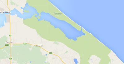
Chundikulam Sanctuary Lagoon
Trying to leave the Jaffna Peninsula travelling by the East Coast Mullaithivu road thru the Chundikulam Sanctuary.

Bad news: Maybe in SUV with a snorkel or trail motor bike.  As Olivier and Benoît (from France) say: The lagoon of Chundikulam Sanctuary, we have to pass in the ocean, no beach road at this season (NE Monsoon).
Maybe possible to cross in May-Oct season.
Related: Crossing Kokilai Lagoon


https://www.google.lk/maps/place/Jaffna/@9.4605176,80.5491221,12z/data=!4m2!3m1!1s0x3afe53fd7be66aa5:0xc7da0d9203baf512?hl=en


Friday, June 12, 2015

Travel Tip: Places to Stay in Mullativu (budget)

Green Lodge, 10 km south of Mulaitivu
Places to Stay in Mullaitivu (reasonable).
(Also see how to cross Pulmuddai/Kokilai/Kokillai Lagoon)

lllllll
About 200 meters north of main drag. Army place on beach

Low end  from Yan Zommer 
Mullativu center there is a Three Starts Lodge on the third or fourth floor of the highest building. Very simple, but extremly cheap.   http://goo.gl/maps/onZfs
 Green Lodge on the Beach
10 km South of Mullaitivu, on the Beach, Green Lodge.  Its just past Catholic Church on East/Left Sea Side 10 km south of Mullativu.  Sign says Green Lodge.  Go straight down the road. Most locals dont know/want to give info.
Green Lodge is run by the Army. Nice chalet like place (see photo). Also a couple of round cottages with bunk beds and outside shared toilet. No electric, generator runs till 11pm.   Speak to a Ranker (i.e. stars on shoulder) to get a contact number.

This place is a little hard to find, and no permanent contact number. Anyone in the know suggest that this gets fixed (a solar powered CDMA phone maybe).

Comments from some visitors to whom we suggested the place.

Caroline/LooseCogs
Once again many thanks for your suggestions and advice about cycling here in Sri Lanka.

We cycled through Mullaittivu and asked various army personnel as to the whereabouts of the Army Hotel. Unfortunately no one spoke English so we weren't sure if we were making sense or not, but we were waved in a northwards direction. Eventually we enquired at a local government establishment where someone spoke English and directed us about 500m up the road. When we enquired there was no room. For future reference it's the right hand turn on the T junction of the North side of the 035 road.

There was a newish lodge in the main High Street, but a Swiss Cycling couple who we had briefly met earlier said it was closed. We took them at their word and didn't investigate further.

We carried on down the coast to find the Green Jackets lodge you had mentioned, the Swiss couple were in front of us, they were faster on a Tandem. We found the road on the left indicating Green Jackets resort and turned down an unsealed road, only to find the swiss couple coming back the other way saying that this too was closed and that no one was there.

They decided to carry on down the coast and see what turned up. We called in at the nearest army garrison and asked a soldier on sentry duty about the Green Jackets resort. We managed to communicate somehow and he phoned his superior who spoke to us on the phone and booked us in.

We returned back down the road to the Resort and a couple of soldiers were waiting for us. We were the only ones there, but it was a very nice setting, and they cooked us a lovely dinner.
Michel and Karin
After 80 km we saw a sign "Green jackets resort". At the end of a dirt road we found some bungalows on a nice beach. The place was empty but after some shouting, 3 young soldiers appeared. They had to call their boss at the camp to ask if we could stay there. The boss said, only accommodation, no food. Karin asked to see their kitchen and after some difficult conversation it was understood that we should give them some money to buy all that was needed for string hopper and curry and that we could buy a fish from the men who where pulling their big net at the beach.
From Blog in Dutch (Google Translate). Unhappily no photos of Green Lodge
Along the way we try to check whether we keep driving, but it was soon clear that no one here understands English. We cycle through beautiful surroundings with every kilometer an army post. This is clearly occupied territory since the war ended six years ago. The further we drive away from Trinco, the less traffic and people are not accustomed whites. They are timid, but when we sway appears the broad smile that we have seen anywhere in this country.

On the lagoon is looking for a boat that will transfer us only with sign language.
Across the road is the equally beautiful. It starts to rain, but no tropical rain, there is best for cycling. Eventually we find accomodation at an army base on the beach. The men do not understand us, and the only word I understand them is the boss. "The symbol for phone to my ear, I ask to call 'boss' and fortunately the English. First he wants to know where we come from ... if you come from the wrong country, maybe you can not stay here? We arrange an overnight stay, but "only accomodation." How do we get to eat then? I try to explain that I want to see the kitchen, I can go shopping and cook, but then says one of the men he's cook. With our money, they want to go shopping for string hoppers with curry and fish. If Michel them suggesting that around here no fish for sale, the man pointing to the fishermen in the sea. They will soon buy the fish, he's still swimming.

Thursday, June 11, 2015

East Coast: How to Cross Kokilai Lagoon

This was meant to be part of a post of travel by tuk-tuk along the East Coast, from Paranthan-Mullativu-Kokilai-Pulmoddai-Trincomalee.  However, there seems to be minimal information about how to get across Kokillai Lagoon. (See Places to stay around Mullativu)

For those who are thinking of traveling by bus/bicycle/motorbike along the East coast of Sri Lanka from Jaffna-Paranthan-Kilinochi-Mullaitivu - Trincomallee - Batticoloa -Arugam Bay, the lagoon at Pulmuddai/Kokilai should not be a deterrent.

Kokilai Lagoon, Kokilai. The other side of the lagoon is Pulmoddai
Just get to the fishing village at either Pulmuddai or Kokilai and arrange with a fisher to take you across. Its about LKR 500 for a person, LKR 1000 or so for a small motor bike and some where in between for a cyclist.  At times there is a boat that can take a tuk-tuk across the lagoon.

If you are traveling in vehicles larger than a tuk-tuk there is detour (42 km ) around the Kokkilai Lagoon.  It should be motorable even by a small car during the dry season.  During the rainy season, as some sections of the road are gravel, small cars might not be able to go over potential mud holes.

For detailed instructions for detour by vehicle see
http://www.wilpattuhouse.com/TravelTips/Crossing-Kokilai-Pulmuddai.html

Travel Tip: Do your Snorkeling etc Before Mid Day

Tide at Galle: Note High Tide is around mid day
In Sri Lanka, if you plan to snorkel, whale/dolphin watch do it as early as possible. Preferably before mid day, be it East or West Coast.  Thats because the tide comes in around mid day and the sea will start to get rougher.  If your snorkeling in relatively shallow water, the sand will get disturbed and your visibility will become low.

In most other countries the tide will change every day and the height too (3-12 feet on average).  So before you go out to sea, need to check tide chart for low and high tide times.

In Sri Lanka the time of high tide (වඩ දිය) and low tide (බා දිය) changes very little. To make things even better we have very little difference in height between low and high tide.  The difference in tide height is about 0.5 m (1.5 feet) in Sri Lanka.

The reason is that Sri Lanka is one of a few tidal node or amphidromic point. That is center point around which the tides rotate. Think of a string you whirl around while moving it very slightly up and down with your hand.  There will be almost no up down (vertical) movement near your hand.  At the end of the sting there is a big up down (vertical) movement.   The amphidromic point will be your hand, the center of rotation.

For more technical/scientific explanation of amphidromic point see here.

Friday, December 19, 2014

Travel to North and East, Sri Lanka. Ministry of Defence Permission

There is a lot of hype about Tourists not being allowed to go to the North (Jaffna, Mannar etc). Its just hype. All you need to do is send a email (or Fax) to the Defence Ministry with some details. Answer is quite prompt andyou have to print out email and carry it with passport.

Even though the Ministry is prompt, I would not hold my breath during long weekends, specially Full Moon Poya days.

If you put down in Purpose of Travel: Promote Self Rule for the North/Tamils, I kind of doubt you would get permission to travel.

http://www.defence.lk/new.asp?fname=Foreign_Passport_holders_traveling_to_the_North_20141030_02
email address "modclearance@yahoo.com"